Agriculture Crop Monitoring
Transform farming with bots that scan, analyze, and report crop health on the spot. Computer vision and AI unlock insights to boost yields, slash waste, and spot diseases early.
Why Automate Agriculture Crop Monitoring?
Maximize Crop Yields
Spot growth quirks and nutrient gaps early enough to fix them and supercharge harvests.
Early Disease Detection
Multispectral cams detect fungi and bugs invisible to the naked eye.
Precision Resource Usage
Target water, ferts, and chems precisely—cutting costs and your eco footprint.
24/7 Autonomous Operation
Runs anytime, rain or shine, no crew needed—covering big fields around the clock.
Scalable Infrastructure
Roll out robot fleets that collaborate to scan growing operations seamlessly.
Data-Driven Forecasting
Build data histories for smarter predictions, better budgeting, and risk management.
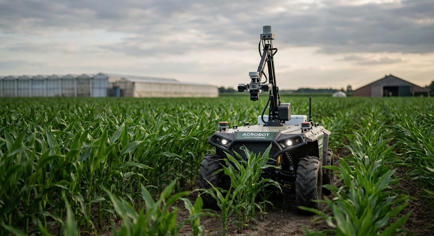
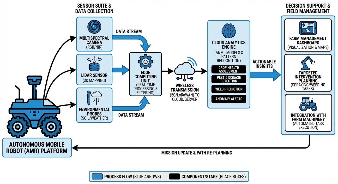
How The Technology Works
RTK GPS and LiDAR guide it down crop rows with cm-level precision, dodging plants and obstacles.
Multispectral/RGB cams capture plant images; edge AI processes them onsite for diseases, water stress, and growth.
Builds a field 'digital twin.' Dashboard delivers health maps, alerts, and sprayer prescriptions.
Where It's Used
Vineyards & Viticulture
Tracks grape vines for peak harvest (veraison) and canopy management in premium wines.
Broad-Acre Farming
Monitors wheat, corn, soy across vast fields for N-maps and weed detection.
Orchards & Fruit Production
Counts fruits for yield forecasts, inspects trees to halt blight in apples, oranges, almonds.
Greenhouses & Vertical Farms
Navigates indoor hydroponics for climate tweaks and mold alerts in humid setups.
What You Need
| Category | Requirements |
|---|---|
| Sensors & Payload | Multispectral Camera (NDVI support), High-Res RGB Camera, RTK-GPS Module, LIDAR (for obstacle avoidance). |
| Robot Capabilities | All-terrain suspension, 4+ hour battery life, IP65/IP67 weather rating, ROS2 navigation stack. |
| Compute & Software | Onboard Edge GPU (e.g., Jetson Orin), Computer Vision Inference Engine, Fleet Management API. |
| Connectivity | 4G/5G Cellular Module or Long-Range LoRaWAN for telemetry, Local Wi-Fi for bulk data offload. |
Frequently Asked Questions
How does the robot distinguish between crops and weeds?
Deep learning trained on thousands of images analyzes leaf shape, texture, spectrum—95%+ accuracy distinguishing crops from weeds.
Can the robot operate in rain or muddy conditions?
IP65+ rating laughs off water, though mud can affect traction. Torque adjustments tackle farm terrain.
What is the battery life and charging time?
4-6 hours per charge standard. Docking stations allow self-recharge for near-24/7 operation.
Does it require an internet connection in the field?
Nope—all processing happens right on the edge, so it stays local. It only connects for uploading reports or updating paths back at base.
How precise is the location data?
RTK delivers 1-2 cm accuracy, letting you revisit and track individual plants over time.
Can it work at night?
Yes—LiDAR for dark nav, LEDs for night cams.
Is the data compatible with other farm management software?
Yeah, exports to GeoJSON and Shapefiles, plus APIs for John Deere Ops Center and Climate FieldView.
What happens if the robot gets stuck?
It tries self-rescue first; if truly stuck, it pings the operator with coordinates and a live camera view.
Can it navigate on slopes?
Low center of gravity tackles 20° slopes safely. Steeper terrain? Custom chassis options available.
Is data privacy guaranteed?
Absolutely—your data, your control. End-to-end encryption keeps your crop insights totally secure.